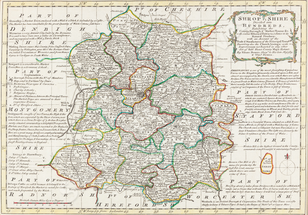
AN ACCURATE MAP OF SHROPSHIRE
divided into its hundreds drawn and compiled from the most approved maps and surveys and illustrated with various additional improvements also, historical extracts relative to trade, manufacture, natural history etc. not extant in any other map of this county
1765
Cartographer: Emanuel BOWEN
Size: 508 mm x 762 mm. Scale: 1 inch = 2.9 miles
Shropshire Archives ref: CM/2/7
Cowling ‘Printed Maps of Shropshire’ 250
This map is taken from The Large English Atlas, published 1750-52 by E. Bowen and T. Kitchin, which was reprinted 9 times in the 18C. Bowen was a map engraver who worked for George II and also Louis XV of France as a geographer. Finely engraved and produced with vignettes, panorama and inset text, this map was the most useful of the period, with additional details for travellers.
The county boundary is a pecked line. Hundreds are shown by a dotted line, and named in block letters. The hills are still shown in profile, shaded to the east, but they are more indicative of the actual terrain than on previous maps. Rivers are depicted by a double line, shaded grey, tapering upstream and named. Most market towns are depicted by a town plan. Borough towns have asterisks to denote the number of parliamentary representatives. There is also a symbol to show the number of ‘modern charity schools’. Villages are represented by a church with an R or V to show if they have a rector or a vicar and ancient religious houses have their own symbol. Parks continue to be shown by a paling fence and the residences within are mapped and named. Post stages are shown on the turnpikes and distances between towns are given. Commons, marshes, heaths and woods are all named. The surrounds are filled with notes of topographic and historical interest for individual towns and antiquities.
